Welcome to Acton's Stream Team


|


| FP7, Fort Pond Brook
|
- Upstream Border: Rte. 111, across from Knowlton Drive
- Downstream Border: RR tracks near Central Street crossing, north of Robbins St.
|
Team: Mark Chandler, Barbara Raab, Karen McCarthy
|
|
|
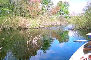
Recreation: Canoeing, Fishing, Scenic Views: Canoeing on Fort Pond Brook, FP7
| |
Segment 1: Starting at the Central Street Bridge and heading south down to the railway tracks. This segment starts with a small pool surrounded by residential property with a minimal buffer zone. It quickly becomes very dense with bushes--posing an almost impenetrable thicket of vegetation. After another 30'-40', the stream opens up into a moderately deep (5'), channel of about 5'-10' width surrounded by wetlands/open marsh. The properties on the eastern side appear distant and well protected. As the stream (@ #5), starts to turn eastward, it becomes more
|
|
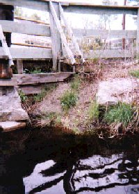
Buffer/Yard Waste/Runoff concerns: Sediment eroding into brook, next to bridge at
Rte. 111, FP7
| |
constricted and in closer proximity to houses, at first on the northeast side and then on the south side as well (a new development). The buffer zone appears marginally adequate (~50'), although moderately to sparsely vegetated (There is a coniferous overstory). Two semi-submerged beaver dams occur there. As the stream heads towards the Railway embankment, it grows up again into a large open wetland, where we observed geese, ducks, and red tail hawks among the larger birds.
Segment 2: North of the Central St. bridge to the Rte. 111 bridge. The stream forms a very sinewy course through an open wetland, interspersed by occasional thickets of bushes overgrowing the rushes and sedges. There is one pond associated with the stream (#19), on which a lawn abuts, clearly contributing
|
|
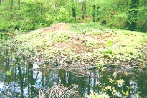
Buffer/Yard Waste/Runoff concerns: Grass clippings on bank of Fort Pond Brook, FP7. Grass clippings, brush, and leaves piled along the streams' edge, or near storm storm drains, "fertilize" the water.
| |
some nutrients to at least the small pond. Generally the stream is navigable by small canoe, except at #13, where an impenetrable thicket of bushes forced us to portage around.
|
|
|
|
|
|