Summary Narrative description:
This section of Coles Brook (FPCL # 2) flows south from Route 2 (Eastbound) to Robinwood Rd. at Hosmer St. The first three quarters of this section are characterized as a forested wetland with a wide stream valley with multiple braiding of a stream that flows slightly over a sandy bottom. Half of this section is visually undisturbed due to the undeveloped land uses or extent of buffering that exists on both sides of the stream. There is a good, healthy habitat marked with dense vegetation and canopy. The last quarter of the stream segment displays a dramatic change with the narrowing of the valley with swift flowing water over a gravelly bottom creating an excellent riffle habitat with pools and runs. Overall the stream is in good shape producing a superior habitat tempered by sections exhibiting negative impact from residential land uses and road runoff.
Section A. - From Rte 2 Eastbound to end of Auto Auction fence
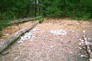
Section A begins at Rte. 2 with Coles Brook flowing downstream through a culvert (P 1) and a man-made channel, bringing with it sand and trash from the
highway. This impact is limited to the first 100 feet. The land use in this section is industrial and commercial, owned by the Auto Auction to the east and Data Instruments to the west.
Overall, this section is characterized as a forested wetland, a red maple swamp with its associated species. There is a wide stream valley with a channel that is in good shape, moving often into braided sections. This is a good habitat section with good food plants, excellent cover and many good snags. There is a red-maple-dominated canopy with dense undergrowth of alder, viburnum, dogwood, and blueberry. The stream bottom is sandy throughout with tea-colored water. The water ranges from one to two feet in depth, flowing slightly.
Two culverts exist in this section; the first is the Rte. 2 one (see above). The second culvert (P 2) was dry and appears to be connected to the Data Instrument parking lot, but was filled with vegetation debris, and no water was flowing on the day of the survey.
FPCL2 Section B – From edge of Auto Auction fence to tributary flowing south from Brucewood (FPCL3)
The land use in Section B is residential on the southwestern part of Coles Brook and continued industrial on the northeast. The channel is well-defined with a wide stream valley and increased frequency of braided sections. Residential encroachment is pushing at the upland edge. Wetland violations are immediately apparent from the residential uses. They include yard waste dumping and hoses pumping water out of the stream. Some of these hoses appear in active use while others are probably non-active. Lawns come right to the edge in a couple of properties with yard waste fill evident along the bank as well as limited clear-cutting in one property.
Several pools and riffles are found in this section as well as evidence of wildlife, caddisfly, mallard ducks and raccoons. There are many good snags. The depth of the water continues to be 1-2 feet, tea-colored, sandy stream bottom, odorless, and moving more swiftly than section A. One culvert was noted in this section.
This section can be described as a good healthy habitat, marked with dense vegetation including an abundance of marsh marigold and viburnum. Some invasive exotic plant species are also present including purple loosestrife, rosa multiflora, and burning bush.
One culvert on the residential side (P 3) was found in this area with water flowing throgh swiftly at a depth of one inch. There was evidence of red algae on the culvert.
FPCL2 Section C – From point of Tributary flowing south on Brucewood to Sandalwood Road.
This section begins in an area of Brucewood (the line between East and West) that is undeveloped. The map indicates the presence of nine undeveloped, residentially zoned parcels abutting the stream in this area.
In the first 75% of this section, two large wetlands join to create a large swamp with multiple streams under extremely dense cover and undergrowth. This area was virtually impossible to navigate on the northeastern side. The southwestern side began with culverts under what appears to be an old cart path, with historic fill. The culverts (P 4 & 5) were draining the wetlands into the stream with swiftly flowing water at 3 inches of depth. There is access to this site from Brucewood and evidence of children creating dams and diversionary ditches, but nothing that significantly disrupted the flow.
Ducks were encountered nesting and Aquatic life (caddis fly nymphs) was in evidence when the composition of the stream bed was checked with a net.
The last 25% of this section displays a dramatic change in the substrates. There is a narrowing of the valley, as the wetlands join, with the water beginning to flow swiftly over the bottom that becomes gravelly and includes small cobbles and very little sand. There is an excellent riffle habitat with pools and runs in this section.
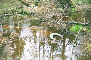
Located at one parcel west of the Sandalwood culvert, there is a small tributary coming downstream from the auto auction land which includes the Clearview Pond, which we did not observe. The small tributary is orange in color, both the
|
|
Trash: Tire in tributary to Coles Brook, FPCL2
| |
water (clear orange) and the stream bottom. As it enters Coles Brook it becomes cloudy and tannic in color. It has a metallic odor. This tributary needs further assessment. Coles Brook clears up within a matter of yards after the convergence.
Overall Section C is in excellent shape, producing a superior habitat. What began as a large stream valley, with multiple braiding at the upstream end on Rte. 2, has now converged into a clearly defined, swift-moving stream.
FPCL2 Section D – From Sandalwood Road culvert to Robinwood Road
This section begins at the culvert (P 6) passing underneath Sandalwood Road. Two storm drains empty into the stream at this point, draining Sandalwood Road. The culvert transports the swiftly moving stream at a depth of 1 foot. The land use of this section consists of developed residential properties on both sides of the stream. The residences on the south side push right to the edge of the stream.
The valley has narrowed, still providing good cover for the stream. The bottom is now exclusively gravel and small cobbles in sand, dark brown in color. There are many riffles in this section with swift moving water. The color of the water has become a much darker tea color.
The vegetation in this area contains more invasive exotic plant species, including barberry and rosa multiflora. The stream changed character at Sandalwood and is well defined at this point. An abutter reported a sucker run every spring in this section.
The residential uses on the stream show some evidence of encroachment including yard waste dumping, burning, clear cutting, erosion, and landscaping activities right up to the edge.
|