- Upstream Border: Gaging Station, near Wheeler Lane.
- Downstream Border: Rte. 2A crossing, between Rte. 27 and Davis Rd.
|
Team: Liz and Dana Kintigh, George Riner
|
|
|
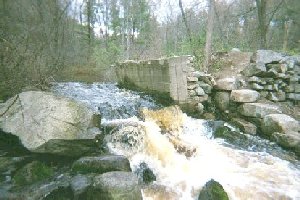
Historic Site: Crumbled spillway of ‘pencil factory'
| |
Beginning where the stream crosses under Rte. 2A, there are paved troughs on both sides of the highway that guide road runoff directly into the stream and are a potential source for pollutants from autos and road salts. The Rte. 2A bridge is crumbling and is in great need of repair. Culverts assist the flow of water under the bridge and under the nearby railroad bed.
Just beyond a sewage treatment plant off Davis Road there is a large dump site abutting and possibly overflowing into the Conservation Land along the brook. This dump is an eye sore as well as
dangerous to anyone exploring around or on it and should be removed. There must be a treated effluent outflow from the treatment plant but we were unable to locate it because we stayed on the other side of the meandering brook.
|
|
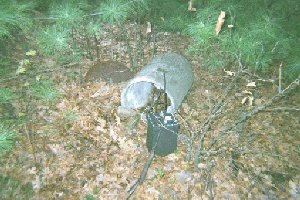
Trash: Railroad battery, stand knocked over, NB3
| |
Scattered areas of trash were found here and there along the brook and a rusting bike was found at the northern end. Along the railroad tracks batteries, once stored in concrete containers, are exposed to the elements. Vandals have tried to disconnect them but have only damaged them. Battery acids are a very real hazard here. New construction planned for along Rt. 27 could be a future hazard and should be monitored.
A railroad bridge crosses the brook south of the Pencil Factory. The ties on the bed are beginning to crumble and should be checked. Otherwise it appears to be stable. Vegetation is growing around and through the railroad bed all along this section.
Stone walls line the brook, meander through the forest and around historic manufacturing sites
|
|
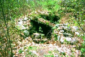
Historic site: "Potato cave", NB3
| |
situated along the stream. A dam was constructed for water power to run a pencil factory forming a broad mill pond upstream. The dam has long since been breached and the pond is now filling as the forest attempts to reclaim it. Towards the northern border a second water powered facility was sited with raceways diverting the water flow. A delightful wooden bridge and two expansive boardwalks allow hikers to cross the brook at the northern end and gain access to paths on the eastern side of the stream.
This is a lovely stretch of the brook with tannin stained clear water flowing over sand, gravel and boulders. The vegetation is thick with hardwoods and conifers through out. Vegetation hangs over the stream with fallen trees in the brook and brush along the banks providing a wealth of habitat for animals. Some small animals were seen as well as a few ducks, frogs and bugs. Fish were not apparent due to the tannin colored water but anglers do come here regularly. If all sections of the brook are as lovely as this one, then we are in great shape.
|