- Upstream Border: Rte 27crossing, near South St.
- Downstream Border: Gaging Station, near Wheeler Lane
|
Team: Norma Wu, Dave Marshall, Jamie Johnson
|
|
|
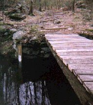
Recreation, hiking: Footbridge access to over 300 acres of conservation land, NB4
| |
Our survey is divided up into four sections: Section 1 is the footbridge at the gauging station to the dam; Section 2 is from the dam to Carlisle Road and Section 3 is Carlisle Road to Route 27.
Section One: is a huge catch basin for steeply sloped land on either side of the corridor. There is an inlet brook that was just boiling with water. The right of way path after the bridge also has lots of run off and is wet most of the year. The biggest threat to this area is on the right hand side of the brook where survey flags come right down to the brook at the right of way! Any development of this hillside would seriously impact runoff and must be very carefully considered.
Section Two: The Robbins Mill Pond Section of Nashoba Brook is looking quite healthy. Above the pond there is a lot of swamp brush and loosestrife which is choking the flow of the
|
|
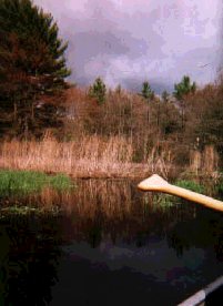
Recreation, Canoeing, Fishing, Scenic Views: Nashoba Brook, NB4
| |
brook. There is a beautiful forest on the right which used to be part of the Marshall property which is now loaded with survey flags right to the stream. This much development if allowed to the stream edge would seriously impact the wetland waterway! Number one priority should be to get a buffer zone donated to the town to keep land owners from cutting down the trees which are now acting as a huge filter for the whole area. Some cleaning out of the stream brush would make it healthier also.
This stream is almost dry in the summer time and gets completely choked off with water chestnuts. It becomes foul smelling. Water will only flow under the dam, not through it and the sluiceway (man made stream) was totally dried up last September. The dam is also in need of repair and further study.
Section Three: The underpass under Carlisle Road is showing some corrosion of the iron pipe. If and when repair is done there, a wider opening should be considered for the high spring
|
|
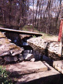
Historic Site: Sluiceway from Grist Mill, NB4
| |
and fall waters. The upper stream is quite narrow and five trees down across the stream meant that we had to portage the canoe several times. We could not make it to Route 27 as the last tree totally blocked passage and there was no dry land to get around.
A serious problem in this section is the presence of: parked vehicles in or on the edge of wetlands, and several sheds, one of which has fallen down into wetlands. There is an appearance of possible filling in of some of the wetland, but none of us are experts on this subject.
|